Chart lessons
Free sectional chart practice
Three full chart lessons from the FAA testing supplement: Norfolk, Virginia (Figure 20), Devils Lake, North Dakota (Figure 26) and Corpus Christi, Texas (Figure 69). Read each cue, then check yourself with the chart questions under it.
Figure 20: Norfolk, Virginia
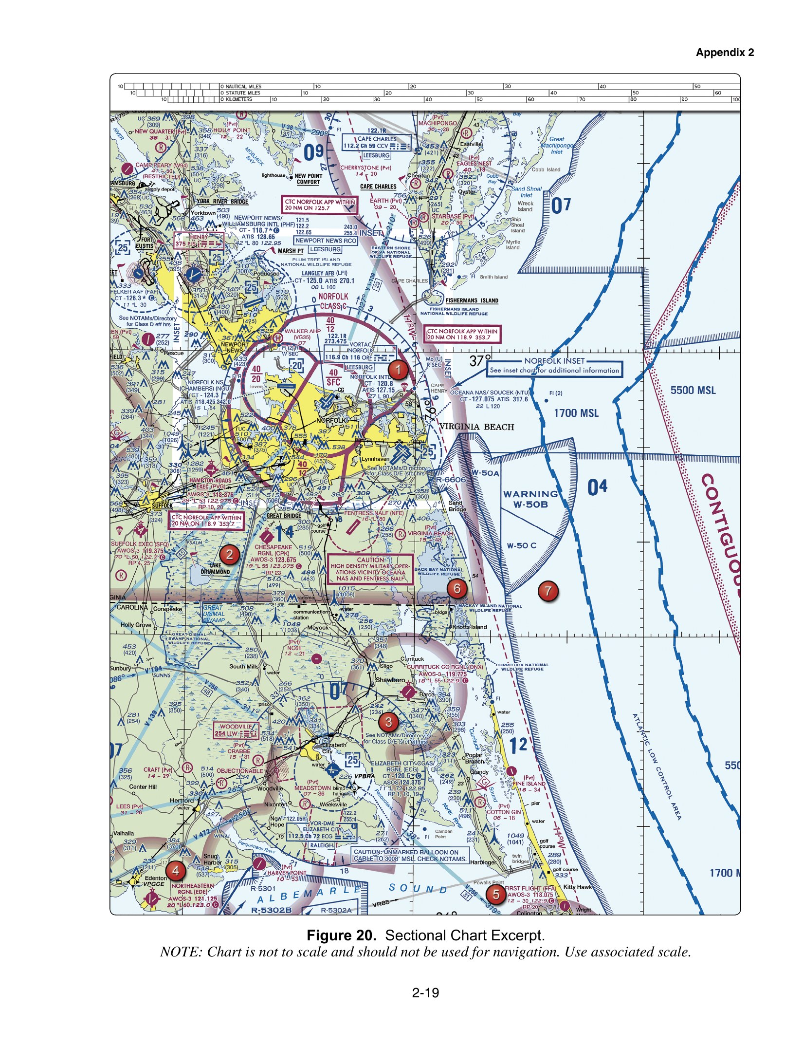
Figure 20. Sectional Chart Excerpt, FAA-CT-8080-2H. Chart is not to scale and is not for navigation.
12 cues
Tap a dashed bracket on the chart, or choose a cue below, to read what that symbol says and why a remote pilot cares.
Questions on this chart
Class C surface area
1. In Figure 20, a contractor wants to fly a roof survey at 150 ft AGL inside the Norfolk Class C area labeled 40 over SFC, beside Norfolk Intl. What applies? (uses Figure 20, open the free chart lesson)
- Class C from the surface to 4,000 ft MSL, so prior ATC authorization is required
- Class D from the surface to 4,000 ft MSL, so authorization is needed only above 400 ft AGL
- Class E from the surface, so no authorization is needed below 400 ft AGL
Show answer and explanation
A. Class C from the surface to 4,000 ft MSL, so prior ATC authorization is required
The solid magenta lines and the 40 over SFC label mark Class C from the surface up to 4,000 ft MSL. Part 107 requires prior ATC authorization for any operation in Class C. The area is not Class D, and authorization is not tied to flying above 400 ft AGL. It is not Class E either, because the solid magenta boundary marks Class C.
Source: FAA-CT-8080-2H, Figure 20; 14 CFR 107.41
Class C shelf floor
2. In Figure 20, the Norfolk Class C label just north of the Norfolk Intl data block reads 40 over 12. Assume the ground under that shelf is 20 ft MSL. Does a drone at 300 ft AGL there need a Class C authorization? (uses Figure 20, open the free chart lesson)
- Yes, because Class C starts at the surface anywhere inside the outer magenta circle
- No, because the shelf floor is 1,200 ft MSL and the drone is at about 320 ft MSL
- Yes, because the 12 means the shelf begins 120 ft above the ground
Show answer and explanation
B. No, because the shelf floor is 1,200 ft MSL and the drone is at about 320 ft MSL
Class C altitudes are in hundreds of feet MSL, so 40 over 12 is a shelf from 1,200 ft MSL to 4,000 ft MSL. A drone at 300 ft AGL over 20 ft ground is at about 320 ft MSL, below the shelf, so 14 CFR 107.41 does not require a Class C authorization for that altitude. Only the inner area marked SFC starts at the surface, and the 12 is 1,200 ft MSL, not 120 ft AGL.
Source: FAA-CT-8080-2H, Figure 20; Chart Users' Guide; 14 CFR 107.41
Tower frequency
3. In Figure 20, which frequency in the Norfolk Intl data block near area 1 is the control tower frequency? (uses Figure 20, open the free chart lesson)
- 127.15
- 116.9
- 120.8
Show answer and explanation
C. 120.8
The CT entry in the airport data block gives the primary tower frequency, which is 120.8 at Norfolk Intl. 127.15 is the ATIS broadcast, which gives recorded weather and airport information. 116.9 belongs to the Norfolk VORTAC box, a navigation aid, not the airport.
Source: FAA-CT-8080-2H, Figure 20; Chart Users' Guide
Part-time tower
4. In Figure 20, the Newport News/Williamsburg Intl (PHF) data block shows CT - 118.7 followed by a star and a C in a circle. What does the star tell a remote pilot? (uses Figure 20, open the free chart lesson)
- The tower operates part-time, and 118.7 serves as the CTAF when the tower is closed
- The airport has a rotating beacon that operates only at night
- The airport is surrounded by Class C airspace
Show answer and explanation
A. The tower operates part-time, and 118.7 serves as the CTAF when the tower is closed
On the sectional legend a star after the tower frequency means the tower is part-time, and the C in a circle marks that frequency as the CTAF when the tower is closed. A rotating beacon is a separate star symbol drawn on the airport symbol itself, not after CT. The airspace here is Class D, shown by dashed blue lines, not Class C.
Source: FAA-CT-8080-2H, Figure 20; Legend 1; Chart Users' Guide
Right traffic pattern
5. In Figure 20, the Chesapeake Rgnl (CPK) data block near area 2 includes RP 23. What does this tell a remote pilot watching for manned traffic? (uses Figure 20, open the free chart lesson)
- Runway 23 is 2,300 ft long
- Aircraft using runway 23 fly a right-hand traffic pattern
- Runway 23 is closed to fixed-wing aircraft
Show answer and explanation
B. Aircraft using runway 23 fly a right-hand traffic pattern
RP followed by a runway number means that runway uses right-hand traffic, so manned aircraft turn right in the pattern for runway 23. Runway length is shown separately as a number in hundreds of feet, here 55 for 5,500 ft. RP does not mean a runway is closed. Knowing the pattern helps a remote pilot see and avoid traffic as required by 14 CFR 107.37.
Source: FAA-CT-8080-2H, Figure 20; Chart Users' Guide; 14 CFR 107.37
Figure 26: Devils Lake, North Dakota
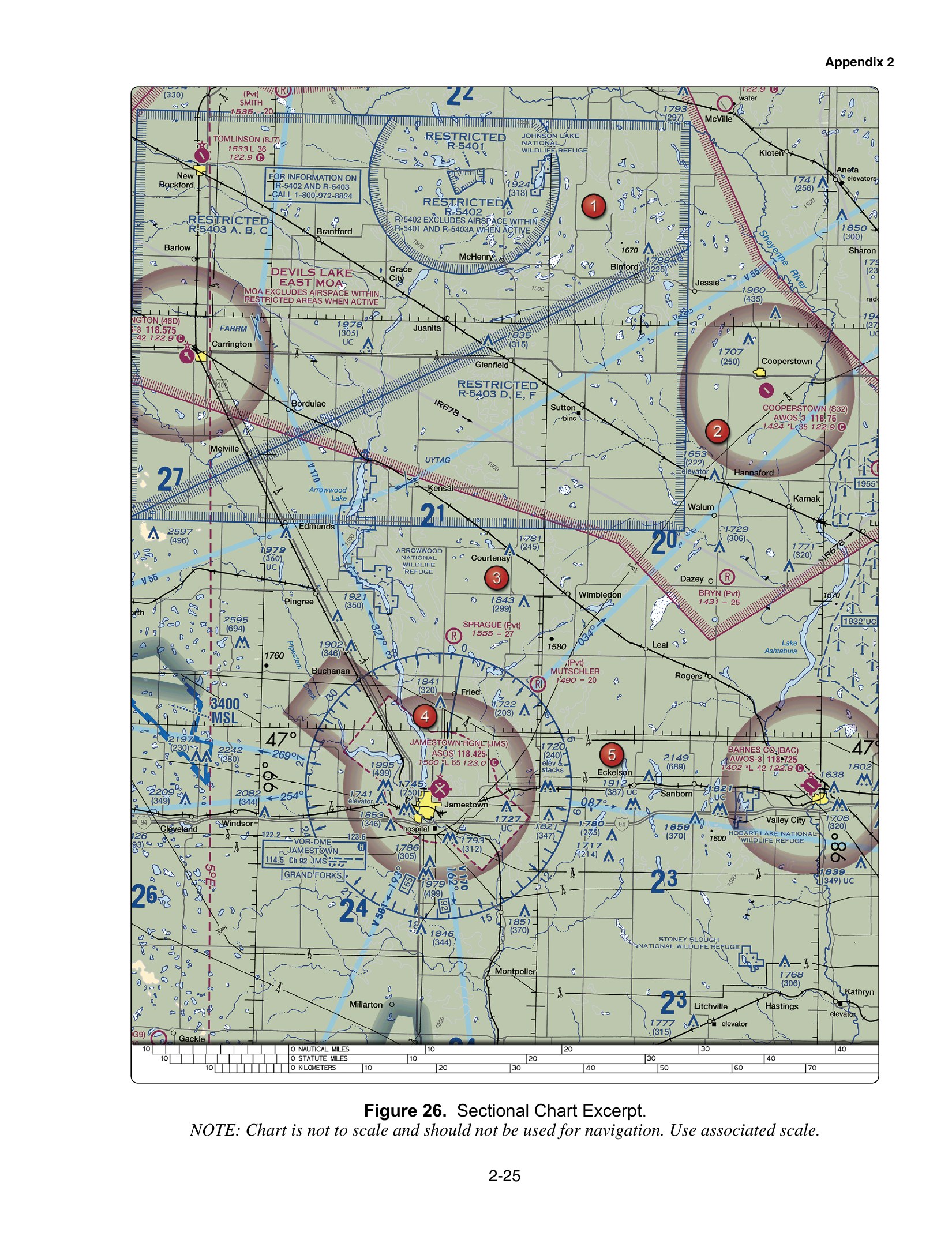
Figure 26. Sectional Chart Excerpt, FAA-CT-8080-2H. Chart is not to scale and is not for navigation.
12 cues
Tap a dashed bracket on the chart, or choose a cue below, to read what that symbol says and why a remote pilot cares.
Questions on this chart
Restricted area
1. In Figure 26, area 1 lies inside the blue hatched boundary of Restricted Area R-5403. What does a remote pilot need before flying there? (uses Figure 26, open the free chart lesson)
- Only a check that the Devils Lake East MOA is not active
- A LAANC authorization from the nearest control tower
- Permission from the using or controlling agency
Show answer and explanation
C. Permission from the using or controlling agency
Part 107 forbids operating in a restricted area without permission from the using or controlling agency. Checking MOA status does not cover a restricted area, which carries hazards such as firing or military testing. LAANC grants access to controlled airspace near airports; it is not permission to enter restricted airspace.
Source: FAA-CT-8080-2H, Figure 26; 14 CFR 107.45
Special use airspace information
2. In Figure 26, a remote pilot wants to learn whether R-5402 and R-5403 are active. What does the chart itself suggest? (uses Figure 26, open the free chart lesson)
- Call 1-800-972-8824, as printed in the box near New Rockford
- Call Jamestown tower on 118.425
- Monitor Tomlinson CTAF 122.9 for activation calls
Show answer and explanation
A. Call 1-800-972-8824, as printed in the box near New Rockford
The boxed note near New Rockford says for information on R-5402 and R-5403 call 1-800-972-8824. Jamestown has no control tower, and 118.425 is its ASOS weather broadcast. A CTAF at a small airport is not where restricted area status is published.
Source: FAA-CT-8080-2H, Figure 26; Chart Users' Guide; 14 CFR 107.45
Military Operations Area
3. In Figure 26, the magenta label DEVILS LAKE EAST MOA marks a Military Operations Area. What does a remote pilot need to fly inside it? (uses Figure 26, open the free chart lesson)
- Permission from the controlling agency, the same as for a restricted area
- No permission is required, but the pilot should check whether it is active and watch for military aircraft
- A LAANC authorization, because a MOA is controlled airspace
Show answer and explanation
B. No permission is required, but the pilot should check whether it is active and watch for military aircraft
A MOA separates military training from IFR traffic, and VFR pilots, including remote pilots, may operate in it without permission. Checking whether it is active and keeping a sharp lookout is the prudent step. Permission is needed only for restricted and prohibited areas, and a MOA is not a class of controlled airspace that needs LAANC.
Source: FAA-CT-8080-2H, Figure 26; AIM 3-4-5; 14 CFR 107.37
Class E 700 ft floor
4. In Figure 26, area 2 lies inside the shaded magenta ring around Cooperstown. What airspace is there from the surface up to 700 ft AGL? (uses Figure 26, open the free chart lesson)
- Class E from the surface, because the airport has an AWOS
- Class D up to 700 ft AGL around Cooperstown
- Class G, with Class E beginning at 700 ft AGL
Show answer and explanation
C. Class G, with Class E beginning at 700 ft AGL
A faded magenta ring means Class E begins at 700 ft AGL inside it, so the airspace below is Class G and a 400 ft AGL flight needs no ATC authorization. A Class E surface area would be drawn with a dashed magenta line, and an AWOS does not create one. Class D needs a control tower and a dashed blue line, neither of which is shown.
Source: FAA-CT-8080-2H, Figure 26; Chart Users' Guide; 14 CFR 107.41
Automated weather frequency
5. In Figure 26, which frequency gives automated weather at Cooperstown (S32)? (uses Figure 26, open the free chart lesson)
- 118.75
- 122.9
- 118.425
Show answer and explanation
A. 118.75
The Cooperstown data block lists AWOS-3 118.75, the automated weather broadcast. 122.9 with the C is the CTAF used for traffic advisories, not weather. 118.425 is the ASOS at Jamestown Regional, a different airport.
Source: FAA-CT-8080-2H, Figure 26; Chart Users' Guide
Figure 69: Corpus Christi, Texas
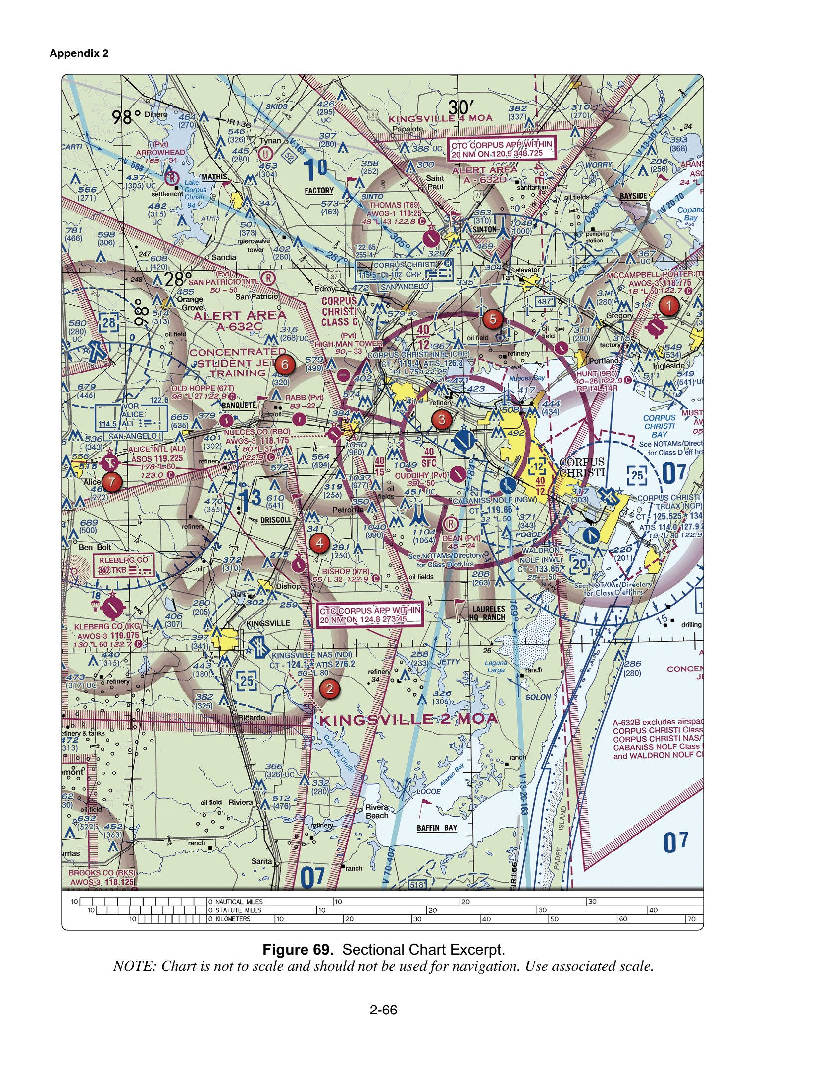
Figure 69. Sectional Chart Excerpt, FAA-CT-8080-2H. Chart is not to scale and is not for navigation.
12 cues
Tap a dashed bracket on the chart, or choose a cue below, to read what that symbol says and why a remote pilot cares.
Questions on this chart
Class C surface area
1. In Figure 69, a real estate photographer wants to fly at 120 ft AGL at area 3, close to Corpus Christi International. What is required? (uses Figure 69, open the free chart lesson)
- Prior ATC authorization, because area 3 is in Class C from the surface to 4,000 ft MSL
- Nothing, because a flight below 400 ft AGL is always under Class C
- A radio call to the tower on 119.4 just before takeoff
Show answer and explanation
A. Prior ATC authorization, because area 3 is in Class C from the surface to 4,000 ft MSL
Area 3 lies inside the inner ring marked 40 over SFC, so Class C starts at the surface and runs to 4,000 ft MSL. Part 107 requires prior ATC authorization to fly there. The surface area has no gap below 400 ft, and a radio call to the tower is not how a remote pilot gets authorization.
Source: FAA-CT-8080-2H, Figure 69; 14 CFR 107.41
Class C shelf
2. In Figure 69, the magenta figures 40 over 12 are printed just north of the Corpus Christi International data block. What do they mean? (uses Figure 69, open the free chart lesson)
- Class C from the surface to 4,000 ft MSL within 12 NM
- Class C from 1,200 ft MSL up to 4,000 ft MSL in that shelf
- Class B from 1,200 ft MSL up to 4,000 ft MSL
Show answer and explanation
B. Class C from 1,200 ft MSL up to 4,000 ft MSL in that shelf
In a Class C label, the top number is the ceiling and the bottom number is the floor, both in hundreds of feet MSL, so 40 over 12 means 1,200 to 4,000 ft MSL. The 12 is a floor altitude, not a distance in NM. The airspace is drawn with solid magenta lines and named CORPUS CHRISTI CLASS C, so it is not Class B.
Source: FAA-CT-8080-2H, Figure 69; Chart Users' Guide; 14 CFR 107.41
Shelf floor calculation
3. In Figure 69, the obstruction 1037 (977) lies near the Class C sector labeled 40 over 15. Using it to estimate ground level, would a drone at 400 ft AGL there be inside that Class C sector? (uses Figure 69, open the free chart lesson)
- Yes; 400 ft AGL is above the 150 ft floor
- No; that sector begins at 4,000 ft MSL
- No; it would be at about 460 ft MSL, below the 1,500 ft MSL floor
Show answer and explanation
C. No; it would be at about 460 ft MSL, below the 1,500 ft MSL floor
The ground is about 1,037 minus 977, or 60 ft MSL, so 400 ft AGL is about 460 ft MSL. The bottom number, 15, is the floor in hundreds of feet MSL, so the sector starts at 1,500 ft MSL and the drone is below it. There is no 150 ft floor, and 4,000 ft MSL is the ceiling, not the floor.
Source: FAA-CT-8080-2H, Figure 69; Chart Users' Guide; 14 CFR 107.41
ATIS frequency
4. In Figure 69, which frequency gives the recorded weather and airport information (ATIS) at Corpus Christi International (CRP)? (uses Figure 69, open the free chart lesson)
- 126.8
- 119.4
- 122.95
Show answer and explanation
A. 126.8
The CRP data block lists ATIS 126.8, the recorded broadcast of weather and airport information. 119.4 follows CT and is the control tower. 122.95 at the end of the elevation line is the UNICOM.
Source: FAA-CT-8080-2H, Figure 69; Chart Users' Guide
Class D ceiling
5. In Figure 69, a remote pilot has authorization to fly in the Kingsville NAS (NQI) Class D near area 2 while the tower operates. Per the dashed blue box with 25, what is the top of that Class D? (uses Figure 69, open the free chart lesson)
- 2,500 ft AGL
- 2,500 ft MSL
- 8,000 ft MSL
Show answer and explanation
B. 2,500 ft MSL
The number in the dashed blue box is the Class D ceiling in hundreds of feet MSL, so 25 means 2,500 ft MSL. Class D ceilings are not charted in AGL. 80 in the data block (*L 80) is the longest runway, 8,000 ft, not an altitude.
Source: FAA-CT-8080-2H, Figure 69; Chart Users' Guide; 14 CFR 107.41
How to read altitudes on a sectional
Numbers stacked like 40/12 inside Class B or C airspace give the ceiling and floor in hundreds of feet MSL: here 4,000 ft MSL top and 1,200 ft MSL bottom. SFC means the floor is the surface. Obstruction labels show the top in MSL with the height above ground in parentheses, so 1049 (980) is a tower top at 1,049 ft MSL, 980 ft AGL. Part 107 limits are in feet above ground level, so convert before you compare. Source: FAA Aeronautical Chart Users' Guide; 14 CFR 107.51.
Related guides
- How to read airspace classes on a sectional chart
- MSL vs AGL altitude math
- Class C airspace for drone pilots
- Class E airspace for drone pilots
- Latitude, longitude and scale on a sectional
- Special use airspace
- More airspace practice questions
- All Part 107 guides
Study the charts on your phone
Sectional Cue has 1150+ original questions with explanations, 27 FAA figures you can tap to read, and timed 60-question rehearsals. About 152 questions and three chart lessons are free.